Discover the particular morphology of Gallarate with an environment characterized by the existence of a flat area traversed by waterways, hilly areas with medium to tall trees, and a gigantic moor.
In the work of the Archpriest Francesco Bombognini Antiquario della Diocesi di Milano dated 1790, which contains a selection of sacred and profane historical news of all the parishes of the Diocese, we read: «Here we are in one of the most famous villages of the whole Diocese. It takes its name from the Gallerita Legion posted there by the Consuls C. Marcello, and Gn. Corneglio, who, long before Christ, triumphed over the Insubres in this area. The victors liked these Hills, and many of them, attracted by the amenities of the site and by the salubrity of the Climate, established their families here, and many of them still exist in this area, their genealogies boasting an ancient nobility.»
Even earlier, in 1541, the Milanese Monsignor and historian Bonaventura Castiglioni in his Galloroum Insubrum Antiquae Sedes, describes the ancient history of his beloved land of Lombardy, writing «From Gallarate, for those looking towards the Alps, begins a valley of marvelous beauty that continues up to the lake of Gavirate. It is crossed by a stream with crystal clear waters called the Arno. To right and left, places built on heights and flourishing villages. I too would be inclined to believe that that small river took its name from the Etruscans who reigned here, that is, from the other Tuscan Arno which today flows through Florence. Due to the similar arrangement of the villages that both are surrounded by.»
Arno river
From these few extracts it is clear how the particular morphology of Gallarate has been appreciated since ancient times for its pleasant views and varied landscape. Gallarate is the only city in the province of Varese to be crossed by a small river, the Arno river, today improperly called Arnetta by the locals. This millenarian river, technically called a “torrent” as it does not flow continuously, originates from the hills near Varese and then ends near Lonate Pozzolo, as indicated in a map of 1772, and has always been a presence for inhabitants of the area, so much so that they have developed a sentimental or even mystical connection with it.
Today, the Arno flows through the Gallarate area for a stretch of about 4 km and is crossed by numerous bridges and bordered by the retaining walls of homes and industrial buildings. The appearance is that of an artificial canal but originally it looked different.
Morphology
On a morphological level, the historic center of Gallarate is a sort of large hollow, a large oval half-basin where, facing a small rise, the current Basilica is located, while at the lowest point, is the present-day central square, an area in which the first village would have originated. Originally, the two river Arno’s and the smaller river Sorgiorile flowed together in the center of the central square where the fountain is located today, to then form a single course along the present-day via Don Minzoni.
Following the research of the aforementioned Sironi, we read in a document from 1580 of how the population asked the provost to open the divine offices to allow those who lived on this side of the divine torrent to be able to hear. These few lines are fundamental in helping us understand the mystical relationship between the river and the population, but also how this same river was often a source of problems with its floods, as well as understand the reasons there are two churches from different eras in the same square. They also help us ascertain that at the end of the 16th century the river was following its original route, or rather, only part of it was.
Centre
In the centre of the city, the river has currently been culverted, and outside the centre, its course has been diverted, having undergone various detours over the centuries. The first occurred in the 12th century in the Middle Ages with the creation of defenses consisting of walls and bastions, which definitively destroyed in 1362, surrounded by a moat into which the Arno and the Sorgiorile were channeled, leaving a third smaller river, called Arnetta, to follow the original route, which served the needs of the village and discharged sewage. 1818 saw the carrying out of works such as the reconstruction of the cover which, however, was not able to solve the flooding problem.
Following the floods of 1843 and 1852, a project was presented to modify the course of the river, and aimed to eliminate its tight curves. Work began in 1862 on a project by Eng. Marino Croci who developed a way to deviate the course of the river further upstream by establishing a new more vertical layout to regularize the course and eliminate unnatural elbows. The part previously occupied by the riverbed, including the river that crossed the center, was then sunk. The last section was modified at the end of the 19th century, and of the original layout, today the structure of the buildings remains, rounded at the point where the rivers flowed.
Final solution
Nonetheless, in the 1900s there were two other major floods: in 1910 and 1951. The definitive solution only arrived in the 2000s with the construction in 2006 of lamination tanks that allow floods to be managed during periods of intense rain. During the century of industrialization, the river contributed significantly to the economic development of the territories it crossed, passing from mills to workshops and finally the mechanical and textile industries, so much so that, after the Second World War, industrial growth consequently led to water pollution.
Today situation
Today, the river is often dry , but thanks to phytodepuration tanks and continual improvements in the quality of the water of the Arno, it has become a naturalistic paradise, very rich in biodiversity, an ideal habitat for many species of birds, some very rare, as well as fish and animals that live along the banks: mallards, ducks, roosters, hens, herons and dragonflies. But there was a time when the river was also popular for fishing and, above all, upstream of Gallarate, for prawn fishing, while the water was used by laundresses.
Each waterway that crosses a city gives it a very special charm, due to the villas and historic buildings surrounded by parks and gardens that overlook it, and due to the presence of vehicular and pedestrian bridges. In the twentieth century, the river Arno was featured in numerous drawings, lithographs and paintings that found a place in the homes of the Gallaratese, continuing to keep the image and its sentimental connection with the city alive.
National Visual Arts Award
In 2016, in its 25th edition, the National Visual Arts Award for the city of Gallarate promoted by the MAGA Museum chose The river Arno and the city of Gallarate as its theme, asking the artists involved to create unpublished works with the river as a strongly rooted element in the collective imagination and representing an inexhaustible source of anecdotes that link the experience of places to the constant flow of its waters.
The invitation was to listen to the emotions and sensations of the body, to reconnect with our origins, to feminine and maternal principles, to slowness and the praise of calm and silence, reminding us that we are all called upon to reflect on how generously the Arno stream has given of and lent itself, adapting to the passage of time and the needs of the area, and serving as everything from a source of food to a dumping ground for industries, even to the detriment of the balance of its own ecosystem.
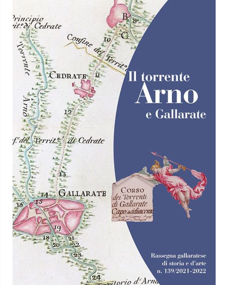
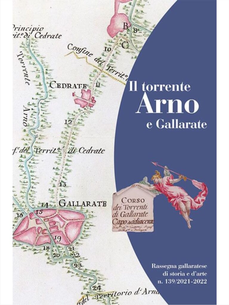
As indicated in the Cultural Heritage and Landscape Code by the Municipal Administration of Gallarate, this historic river currently needs a redesign aimed at the redevelopment of its banks which would allow the city to repossess itself of a fundamental sign of its history. In the photo is the dust jacket of the book The Arno and Gallarate river, published by the Gallaratese Society of Patri Studies in 2022, depicting the unpublished survey of 1760-61, part of the eighteenth-century hydrogeological study preserved in the Milan State Archive, edited by the Jesuit of Brera Antonio Lecchi and the Barnabite mathematician Francesco De Regi, showing the city of Gallarate in its typical medieval oval shape.
San Cristoforo
The choice of the the city’s patron saint, San Cristoforo, is not accidental, as is true in many places near waterways; in fact, he is usually invoked after the flooding of rivers, but is also as the patron saint of wayfarers, pilgrims and motorists, and in general of those who involved with transport. Christopher was an imperial soldier converted to Christianity by the bishop of Antioch Babila and, advised by a monk, he retired to live by a river in defiance of the pagan deities, who were believed to be able to cause disastrous natural events, such as river floods, on a whim.
The holy Christian monks and hermits, settling in those places, challenged superstitions and swept away pagan mythologies, demythologized nature, reducing it to creation, subservient to a creator who had placed his laws in it and who was, instead, benevolent, far removed from whims or unpredictable instincts, who was and is a friend of man and of all creatures. At the river, he carried out his charity in support of travelers who had to cross the dangerous waters in times when there were no bridges and the dangers were many. Legend has it that one night, a boy asked to be helped across the waters and he loaded the boy on his shoulders, and that as he walked, he felt the weight increasing on him.
The legend
Once he reached shore he discovered that the boy was the Child Jesus and that the weight he was carrying on his shoulders was the weight of the whole world. The very name of Christopher is closely related to this mythological episode: it derives from the late Greek name which means “bearer of Christ”. Christopher’s sense of charity lies in that mythological gesture which means: whoever serves a creature serves Jesus himself, and that we know where every act of charity begins and we don’t know where it ends, leading to us to give all of ourselves. Christopher died as a martyr in Lycia, in present-day Turkey, in 250, during the persecution of Decius.
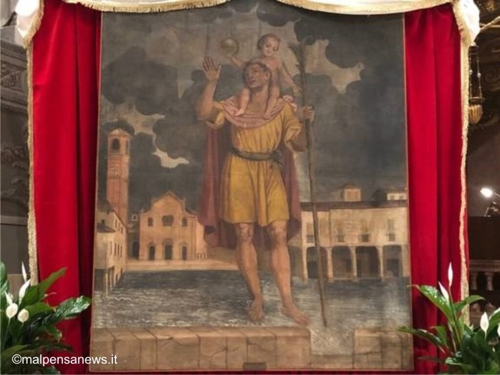
In the Basilica of the city there is a tapestry by an unknown artist dating back to the first half of the 18th century depicting San Cristoforo painted in front of the ancient parish church with his feet in the Arno. The church portrayed is the fifteenth-sixteenth century collegiate church later demolished in the nineteenth century and replaced by the present-day more imposing church, while the bell tower is the same. The Saint is traditionally depicted as a giant crossing the waters, in this case the Arno, with the Child Jesus on his shoulders. Photo www.malpensanews.it
Moorland of Malpensa
The Brughiera della Malpensa (moorland of Malpensa) has undergone many changes over time. Where today there is an airport, a military airfield and barracks were once built, and before that again, a colonial farmhouse. Until the Middle Ages, the area, which was part of the Duchy of Milan, was never exploited due to the acidity of the soil which did not allow cultivation. It was during Austrian rule that the first changes were seen following the edict issued by the Empress Maria Theresa of Austria in 1779 which ordered the sale of all the moors and uncultivated lands of the municipalities to buyers willing to make them fertile and usable.
All the ground on the land purchased between 1783 and 1789 underwent significant transformation when reclamation work began. The new building “Cascina Malpensa” appears on the cadastral map of 1790, the name of which derives from “Mal pensàa”, a phrase in dialect which means “badly thought out” referring to the bad deal of purchasing land that was not very fertile. The farmhouse occupied an area of “9000 cubic meters, in which 24 peasant families lived, therefore about 150-160 people. Roads were built and lined with mulberry trees, vines, and fruit trees.
Uncoltivated land
The main activities carried out were the production of wine and the breeding of silkworms. Until the first half of the 19th century, the area consisted of vast flat sections of uncultivated land with heather and sparse broom bushes which were located near populous towns, and which attracted the attention of individuals and governments interested in attempting reclamation of the land. Alessandro Manzoni was the owner of a large portion of the Malpensa farm from 1814 to 1849, presumably thanks to the influence of his spiritual guide Luigi Tosi, canon of the Basilica of Sant’Ambrogio Maggiore in Milan, who in 1812 received from his brother the rest of the entire property inherited from their father, Giovanni Battista Tosi, a wealthy merchant from Busto Arsizio.
Giovanni Battista Tosi
In 1823 Tosi was elected bishop of Pavia and in 1839, decided to sell all the properties to the Galbiati family up to the lawyer Casanova. The decline of the farmhouse began in 1832 when the lands were expropriated by the Austrian government who used them for summer exercises of the troops and as a place to isolate horses during periods of infectious diseases. From 1861, with the unification of Italy, it became the barracks of the Savoy Cavalry regiment. In 1886, the farm and the buildings were expropriated by the war ministry of the Kingdom of Italy and the area became state property for military operations by mounted troops.
The inhabitants were transferred to surrounding farmhouses and reclamation operations ceased, while the reclaimed land returned to its original state, that of uncultivated moors, with the consequent decay of fruit trees and vines. Everything fell into disrepair, but this transition was the turning point in the development of Italian aeronautics, with the arrival in 1909 of the Caproni brothers from Trentino in search of a free flat space to test their all-Italian flight apparatus. In the meantime, industry also progressed in the area thanks to the 1901 inauguration of the hydroelectric plant of nearby Vizzola Ticino in the presence of Vittorio and Elena di Savoia, who left Gallarate train station in a horse-drawn carriage, and were escorted by cavalrymen to the Malpensa camp.
Military operations
The military operations contributed to the cultural and social development of the city. In fact, these activities always attracted a large number of onlookers and visitors, thanks to the presence of the King himself, who stopped in Gallarate with its railway station. The most memorable maneuver is that of 1885 which took place between the 8th and 12th September, and involved the countryside between Gallarate and Cassano Magnago. To commemorate the Count of Turin’s stay in Gallarate between 1908 and 1912 as inspector of the cavalry, an inscription was placed in the Peroni house in via Don Minzoni.
The members of the royal family were hosted at the Mazzucchettli villa called “la Glorietta” on the hills of the Ronchi di Gallarate, while the officers were guests of the noble Della Croce family . Young people were often to be seen in the streets of the city, attracting the population’s attention as they frequented the café and casino of the theatre. The presence of soldiers from all over Italy made it possible to learn about conventions and customs from other regions. The activity that linked Gallarate with the Malpensa moor was the sport of hunting.
In 1882 the Milanese Society for Horse Hunting was founded by Count Felice Scheibler, who as early as 1880 began organizing deer hunts. Various hunting parties were organized on the moors, with members meeting first in Piazza Pasquè, present-day Piazza Garibaldi. The prey were hares, roe deer or deer, some even arriving from abroad such as a deer from England which was recaptured in a farmhouse between Ferno and Samarate. These prey were chased by twelve foxhounds which were housed in kennels in Gallarate, then Oleggio and finally Sixth Kalends.
Alba Bernard
From the memoirs of the journalist, writer and historian Alba Bernard, we read how important hunting was as a way of showing off the fashion of the time: the officers were dressed in dark jackets with high buttoned-up collars, and with gold braid on the sleeves, the gentlemen had green frock coats decorated with large white cravats and pins, while observers wore tall gray or black top hats and frock coats over long trousers. The ladies who took part in the hunting parties wore short jackets in dark cloth closed by a series of buttons, a full skirt of the same fabric over tight-fitting trousers, leather boots and a black top hat of a slightly different shape from the men’s.
The novices wore a green suit with gold buttons and a black velvet cap, while the master and field master wore a red tailcoat and black cap. Some royal members took part, above all King Umberto I of Savoy, as well as rich landowners and captains of industry such as the Ponti’s, Cantoni’s and Piantanida’s. The company was dissolved in 1899 but the people of Gallarate continued their fashionable meetings often with Count Giacomo Durini at their center, until 1915 which saw the outbreak of the First World War.
Over the years, these meetings attracted numerous illustrious guests: Vittorio Emanuele III, Minister Sarocchi, Cesare Macchi, Benito Mussolini, then director of the People of Italy, Amaldo Agnelli, the prefect Farello, Alfredo Lombardo, Emilio Sacconaghi, Carlo Macchi, Giovanni Bossi, Stefano Rossi, Umberto of Savoy, and Major General Maggiotto. Sumptuous banquets were organized at the Tre RE hotel in Piazza Garibaldi and at the Leon d’Oro in Via Cavour. In addition to political figures, men of letters, intellectuals, journalists, photographers and painters also took part in outings on the moors.
Among them Gabriele d’Annunzio, who wrote:
«… the dogs go among the light heather
With raised tails and low muzzles
In front of the foreman who trains them
For mid-October to the long pursuits.
A clear squeak is heard in those silences
The sound of the horn calls those who stray…»
Part of the Malpensa moorland which has been left uncultivated is now a wonderfully suggestive place and one of the most beautiful moorlands in Northern Italy – a natural treasure, a south-eastern outpost of vegetation typical of the Atlantic coasts and therefore very rare in Italy. In September, it turns purple due to the spontaneous vegetation that grows in the moor’s sterile soil, such as heather.
Via Gaggio
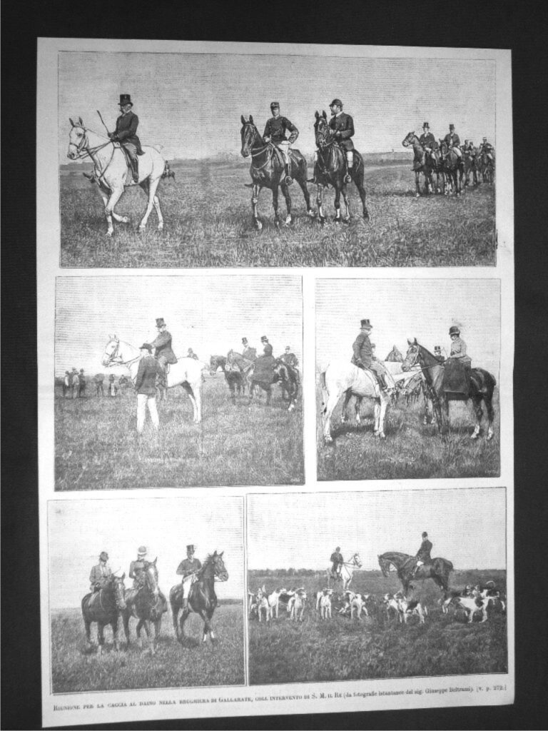
To visit it, either walk or cycle along the beautiful via Gaggio, a wide dirt road of about 2.5 km of medieval origin which, from Lonate Pozzolo arrives at the former Austro-Hungarian customs house, today one of the headquarters of the Ticino Park. Continuing along the avenue, you reach the small piazza in the village of Tornavento, elected the most beautiful village in the province of Varese in 2019, which offers a striking view of the Ticino park. In the photo is a page from a magazine of the time depicting King Umberto I of Savoy during a deer hunt on the Gallarate moor in 1890 with snapshots by Giuseppe Beltrami.
Return to Gallarate
